
Introduction
On the Edge
On the first of January 1993 all customs formalities at internal borders of the EU member states were abolished. Accordingly, the representation of borders on maps of the EU – and more specific, those of border regions within the EU – seem to have lost attention and precision, too. Only simple lines cover the complexity, diversity and constant shifting character of the inner borders of the EU.
In reality, crossing a border at a specific place and time, one is still confronted with barriers. That confrontation, but also the spirit of the EU member states is perhaps the most tangible in those border regions. Especially in these times: on the eighteenth of March 2020 the border between Belgium and the Netherlands was closed due to the pandemic crisis Covid-19. However, the border between Germany and The Netherlands remained open. As such, the borders were back on top of the priority list of things to talk about. So, the simple line on the map representing the border should not only cover the complexity, diversity and constant shifting character of the inner borders, it should also contain the different realities where the border has been placed. As stated by Haselberger:
“All the maps and atlases with which we are familiar confront us with a particular geopolitical picture of the world. It is a world’s surface divided into distinct state territories, each clearly demarcated by a line – the state border – and illustrated in a separate colour. This jigsaw of states is usually taken for granted, as if borders are built for “eternity” and moreover as if the underlying concept is clear and well-defined. (…) However, borders are not just “visible lines” in space or on a map; on the contrary they are complex social constructions, with many different meanings and functions imposed on them. Planners are advised to acknowledge these nuanced and underestimated impacts on space and people as they are decisive for the success or failure of planning endeavours.”
Beatrix Haselsberger (2014) Decoding borders. Appreciating border impacts on space and people, Planning Theory & Practice, 15:4, 505-526, DOI: 10.1080/14649357.2014.963652
The initiative ITEM (Institute for Transnational and Euregional cross border cooperation and Mobility of Maastricht University) based in the border region Euregio Meuse-Rhine endorses this. On their website they describe:
“(…) some of these borders are obvious and hard. They are anchored in the landscape and/or, for example, in the law. Other boundaries seem softer, they appear to be historically grown implicit rules. They may be less identifiable, but sometimes at least as tough as the obstacles we can point out.”
https://itemcrossborderportal.maastrichtuniversity.nl
In this context, the project ‘Border Encyclopedia’ is an attempt to find other ways of representing the local manifestation and productivity of borders. In order to create a multiplicity which adds up to a richer palette and, as such, doing more justice to the richness and complexity of border regions and their raison d’être: the borders within them.
Le Raison d’Être for Border Regions
There are cases in which the border on the map is emphasized for political gain. However, this is less the case within border regions. Borders in border regions within the EU are generally accessible and easy to cross. With no restriction for goods or people, the purpose of multiple abandoned customs posts is to recall an earlier era in which going to another country caused some ‘ID-stress’.
Border regions owe their raison d’être to the presence of internal borders. If they weren’t there, there wouldn’t be a border region. The role of the border is therefore essential and influences the specific quality of life within these regions. Nevertheless, the border is often simplified and there is a constant urge to eliminate, minimize or ‘erase’ it. ITEM describes borders as:
“obstacles that, once removed, can contribute to economic prosperity”
https://itemcrossborderportal.maastrichtuniversity.nl
The Euregio Meuse-Rhine for example states on its website that its goal is:
“(…) to enable people and visitors in the region, regardless of borders, to improve their quality of life through information, communication and cooperation in the five partner regions.”
http://www.euregio-mr.com/nl
A specific quality of life in border regions is the ability to cross borders as part of daily life. Wouldn’t it be better to look for a better quality of life starting from the fact that the border is inevitable and thus from its strength and presence? From this perspective, the border should be given all the attention and prominence on maps.
The Black Line
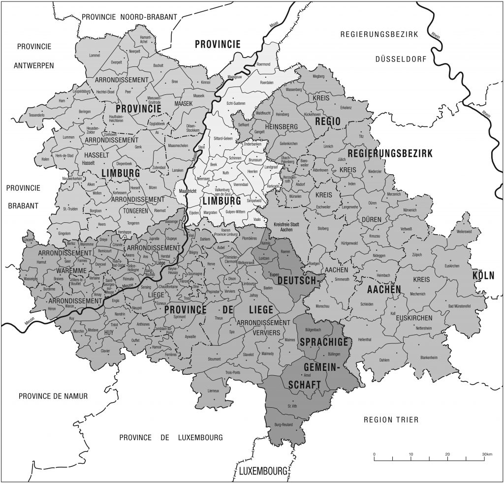
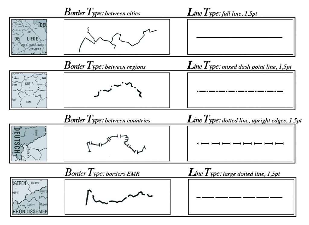
The aesthetics of the border on the map of the Euregio Meuse-Rhine, for example, is limited to four line types, representing boundaries between municipalities, regions & communities, countries and the outer border of the border region itself. This does not appear to be much different on maps of other border regions. The simplistic representation of the border does – of course – not represent the rich variety of border experiences and the impact of that border on its context. ITEM lists them on their website:
“(…) national borders, language borders, cultural borders and the nuances within borders that they indicate as hard and obvious, softer or historically grown.”
https://www.maastrichtuniversity.nl/item, consulted in 2019
These nuances and differences are thus often reduced to a black line in a few slight variations.
If we represent and reduce the border in a border region to one simplistic and stripped-down black line repeatedly, then the opposite risks to happen. Namely that we think too simplistic and one-sided about that physical border region based on the existing map and the simplistic black line. *Seeing like a state
All the above leads to the question: How to elaborate the current representations of border regions on maps, of mostly hard black lines on (almost) white surfaces, to do justice to the everyday life in these regions? Endorsing the importance to map the multi-facetted character of the border to be able to work with the full complexity of such a specific and rich region.
Aim
The aim of Border Encyclopedia is to find other ways to represent the inner borders of border regions. Not to replace other ways of representation (so also ‘the black line’ does not need to be replaced) but to add new, cartopologcial ways to capture and document the border and its performativity.
[MV1]@Ruth, klopt dit?
[MV2]Doe je dat nog per studio?
[RK3]Wilde dat juist niet doen, maar als je denkt dat dat beter is dan zet ik dat er ook bij.
[MV4]Ja, hoe preciezer hoe beter